News Summary
A Severe Thunderstorm Alert has been issued for Lexington and Richland Counties in South Carolina. Strong winds up to 50 mph and marble-sized hail are expected. Residents are advised to secure loose items and stay indoors. Key areas impacted include Columbia and West Columbia, with traffic disruptions noted on several highways. Lightning is also expected to be a significant hazard during the storm. This alert remains in effect until 2:30 p.m. today, reminding everyone to prioritize safety amidst the severe weather.
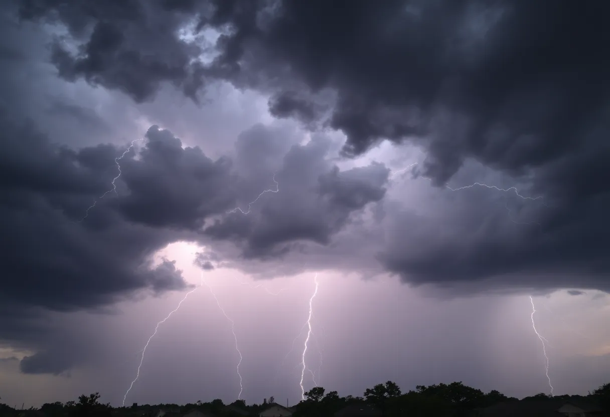
Severe Thunderstorm Alert Hits Lexington and Richland Counties!
Heads up, folks! If you’re in the vibrant cities of Lexington and Richland Counties in South Carolina, it’s time to pay attention. A Severe Thunderstorm Alert has been issued, and the weather is about to take a turn. The rainclouds rolled in just after 2:00 p.m. and are expected to linger, bringing strong storms until around 2:30 p.m. today.
What to Expect
So, what can you expect during this storm? Well, prepare for some action. Wind gusts could reach up to 50 mph, which is strong enough to knock down some tree limbs and send outdoor items flying! If you have anything loose in your yard, like lawn chairs or potted plants, it might be a good idea to bring those inside!
And if you’re thinking that’s all, think again! The storm is also expected to bring marble-sized hail—yep, that’s about half an inch in size. Those little icy balls could potentially cause minor damage, especially if they hit something like a car or an outdoor area.
Where Is the Storm Hitting?
The thunderstorm isn’t particular about where it strikes, so it’s going to flutter around a bit. Major areas impacted include:
- Columbia
- Lexington
- West Columbia
- Cayce
- Irmo
- St. Andrews
- Highway 6 at Lake Murray Dam
- Red Bank
- Oak Grove
- South Congaree
- Pine Ridge
- Columbia International University
- Harbison State Forest
- Riverbanks Zoo
- Columbia Metro Airport
- West Columbia Riverwalk
- Ballentine
- Pelion
Traffic Alert!
If you’re on the road, take it slow! Several highways are affected too, including:
- Interstate 126 between mile markers 0 and 3
- Interstate 20 in South Carolina between mile markers 47 and 71
- Interstate 26 between mile markers 94 and 115
Watch out for hydroplaning, which happens when water builds up in front of your tires, making your vehicle slide uncontrollably. Stay vigilant!
Lightning Safety
Besides the wind and hail, we’ve also got some serious lightning to deal with. The storm is likely to generate frequent cloud-to-ground lightning—which is no joke. In fact, lightning strikes the U.S. a whopping 25 million times each year, causing an average of 20 fatalities annually. It’s safest to stay indoors during the storm and keep an eye on your local radio or TV for updates.
Final Thoughts
To wrap it all up, this alert is very much in effect until 2:30 p.m. today. It seems like a perfect opportunity to cozy up at home, perhaps with a good book or a movie, while Mother Nature throws a bit of a tantrum outside. So, gather your loved ones, take shelter, and let the storm pass. Stay safe and keep your spirits high, Lexington and Richland Counties!
Deeper Dive: News & Info About This Topic
HERE Resources
Governor McMaster Implements Centralized Weather Closure Policy
Severe Weather and Flooding Continues to Threaten Kentucky
Severe Storms Cause Widespread Damage in Minnesota
Warm and Friendly Weather Awaits Central South Carolina
Severe Weather Threat Looms Over Columbia, South Carolina This Weekend
Columbia High School’s Field Day Showcases Future Tech Skills
Unseasonably Warm April and Wild Weather Ahead in Columbia
Celebrate Easter Weekend with Fun Activities in Columbia, S.C.
Severe Thunderstorms Expected in Columbia, S.C. Monday
Severe Weather Alert: Strong Storms Expected in Columbia, SC
Additional Resources
- Myrtle Beach Online
- Wikipedia: Severe Thunderstorm
- Herald Online
- Google Search: Severe Thunderstorm
- Kentucky.com
- Google Scholar: Severe Thunderstorm
- ABC Columbia
- Encyclopedia Britannica: Severe Weather
- Island Packet
- Google News: Severe Weather Alerts
- The State
Author: STAFF HERE LEXINGTON WRITER
The LEXINGTON STAFF WRITER represents the experienced team at HERELexington.com, your go-to source for actionable local news and information in Lexington, Fayette County, and beyond. Specializing in "news you can use," we cover essential topics like product reviews for personal and business needs, local business directories, politics, real estate trends, neighborhood insights, and state news affecting the area—with deep expertise drawn from years of dedicated reporting and strong community input, including local press releases and business updates. We deliver top reporting on high-value events such as Woodland Art Fair, Crave Food and Music Festival, and Railbird Festival. Our coverage extends to key organizations like Commerce Lexington and Blue Grass Community Foundation, plus leading businesses in education, manufacturing, and technology that power the local economy such as University of Kentucky, Toyota Motor Manufacturing, and Lexmark. As part of the broader HERE network, including HEREBowlingGreen.com and HERELouisville.com, we provide comprehensive, credible insights into Kentucky's dynamic landscape.


