News Summary
As severe weather looms, North Carolina residents are urged to prepare for strong thunderstorms tonight. With alerts already in effect for multiple counties, including flash flood warnings and power outages reported, safety is a top priority. The weather could bring damaging winds and large hail, challenging the state after a recent rain. Friday’s forecast indicates more storms could be on the horizon, and weekend temperatures are expected to drop significantly. Residents should remain vigilant and keep informed of updates during this unpredictable weather pattern.
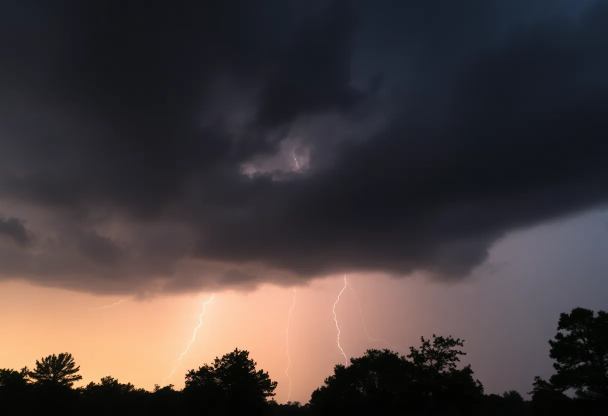
Severe Weather Approaching North Carolina: What to Expect
As evening falls over North Carolina, residents better brace themselves! A slow-moving front is expected to sweep through the state tonight, bringing along a mix of scattered showers and numerous storms. The Upstate and the Midlands are particularly poised to face some serious weather tonight!
Storm Alerts in Effect
As the hours tick away, strong and severe thunderstorms could crash onto the scene later this evening. Forecasters are warning of damaging winds and possibly large hail, so make sure to stay updated on local weather alerts. A severe thunderstorm warning is already in place for sections of Davidson, Guilford, Randolph, and Montgomery counties, which will last until 8:15 p.m. A flash flood warning is also in effect for southern Wilkes County until 9:45 p.m.
It’s not just about the thunder; we’ve already seen rainfall totals of 1-3 inches in Wilkes County on Thursday night. And the stormy weather isn’t isolated either—thunderstorm warnings have been issued for several counties, including Surry, Stokes, and Patrick.
Power Outages Reported
As if the weather couldn’t get any crazier, Duke Energy reported a substation outage in Rolesville affecting around 7,100 customers. It seems a small animal had a hand, or rather a paw, in damaging some equipment. In Harnett County, a tree came crashing down on power lines amidst Thursday night’s storms. Talk about a rough night for many!
Friday’s Forecast: A Mixed Bag
Looking ahead to Friday, the weather will start off in the 60s and climb toward a pleasant high near 80 degrees during the day. But hold on—just when you think the skies may clear, another round of showers and storms could be rolling into the Pee Dee and Low Country by Friday afternoon. Isolated severe storms are on the table once again, so keep your guard up!
Weekend Weather Woes
And if that wasn’t enough, the weekend forecast brings a bit of uncertainty with it. As a cold front makes its way through, temperatures will take a tumble. Expect highs to drop from the low 80s on Friday down into the upper 60s to lower 70s on Saturday and Sunday. Get your rain gear ready because the increased risk of flooding could make for an unsettling time!
Long-Lasting Storm Activity
If you’re hoping for a break in the weather, you may want to hold off on any plans for the upcoming week. Meteorologists predict ongoing storm activity through early next week! A developing surface low over the northern Gulf Coast could stir up not just rain, but rounds of potential storms from Monday through Wednesday. Definitely not what anyone wants to hear!
Safety First!
In light of these unpredictable weather conditions, it’s crucial to seek shelter during thunderstorms. The National Weather Service emphasizes staying alert and monitoring your local channels for further updates. They even offered an overview of how to handle hydroplaning, along with some tips for staying safe during storms.
North Carolina, as the storm system approaches, remember to stay safe and keep an eye on the skies. It’s a wild weather ride ahead, so let’s weather the storm together!
Deeper Dive: News & Info About This Topic
HERE Resources
Severe Winter Weather Forecasted for South Carolina
Severe Thunderstorms and Tornado Risks in Columbia, SC
Severe Thunderstorm Alert for Lexington and Richland Counties
Changes Ahead for State Office Closures in South Carolina
Severe Weather Threat Looms Over Columbia, South Carolina This Weekend
19-Year-Old Arrested for Causing Massive Jones Road Wildfire
Carolina Wildfires Prompt State of Emergency and Evacuations
Myrtle Beach Faces Wildfire Crisis Amid State of Emergency
Wildfires Rock North and South Carolina
Easter Festivities Unite Families in Lexington County
Additional Resources
- WYFF4: Extreme Hail Threat
- Weather.com: Raleigh, NC
- Charlotte Observer: Weather News
- Wikipedia: Weather
- Google Search: North Carolina severe weather
Author: STAFF HERE LEXINGTON WRITER
The LEXINGTON STAFF WRITER represents the experienced team at HERELexington.com, your go-to source for actionable local news and information in Lexington, Fayette County, and beyond. Specializing in "news you can use," we cover essential topics like product reviews for personal and business needs, local business directories, politics, real estate trends, neighborhood insights, and state news affecting the area—with deep expertise drawn from years of dedicated reporting and strong community input, including local press releases and business updates. We deliver top reporting on high-value events such as Woodland Art Fair, Crave Food and Music Festival, and Railbird Festival. Our coverage extends to key organizations like Commerce Lexington and Blue Grass Community Foundation, plus leading businesses in education, manufacturing, and technology that power the local economy such as University of Kentucky, Toyota Motor Manufacturing, and Lexmark. As part of the broader HERE network, including HEREBowlingGreen.com and HERELouisville.com, we provide comprehensive, credible insights into Kentucky's dynamic landscape.
