News Summary
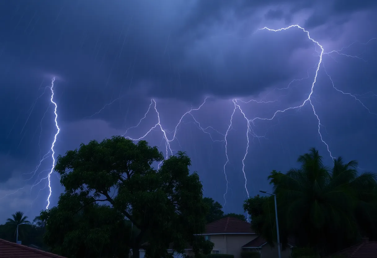
A severe thunderstorm warning has been issued for Lexington and Richland counties by the National Weather Service. The warning is effective until 8:15 p.m. The storm, moving southeast at 20 mph, poses risks of strong winds up to 60 mph, potential damage to trees and powerlines, and heavy rain. Safety precautions include seeking shelter in a low interior room and staying informed about road conditions, as several highways in the area are affected.
Severe Thunderstorm Warning for Lexington and Richland Counties
Hey there, folks in Lexington and Richland counties! Hold onto your hats because the National Weather Service (NWS) has just issued a severe thunderstorm warning. This announcement came at about 7:29 p.m. on Friday and will be in effect until 8:15 p.m. This storm ain’t playing around, so it’s time to take some precautions!
What to Expect
This thunderstorm is currently brewing near the Harbison State Forest and is heading southeast at a speed of 20 miles per hour. That means it could whip up some wind gusts reaching as high as 60 mph. Keep an eye out, because the NWS is warning us about possible damage to trees and powerlines. That’s certainly not something you want near your home!
Areas Affected
If you live in or around these areas, you’re on high alert:
- Columbia
- Lexington
- West Columbia
- Cayce
- Irmo
- Forest Acres
- Springdale
- St. Andrews
- Highway 6 at Lake Murray Dam
- Dentsville
- Oak Grove
- South Congaree
- Pine Ridge
- Arcadia Lakes
- Columbia International University
- Killian
- Harbison State Forest
- Riverbanks Zoo
- SC State Farmer’s Market
- Woodfield
Highway Alerts
And it’s not just neighborhoods that are under threat. Several highways are affected too:
- Interstate 126 between mile markers 0 and 3
- Interstate 20 in South Carolina between mile markers 57 and 79
- Interstate 26 between mile markers 95 and 118
- Interstate 77 between mile markers 0 and 29
Safety First!
So, what should you do? First of all, try to find a safe spot! The NWS advises heading to an interior room on the lowest floor of your home. If you can’t get inside, it’s best to steer clear of areas where falling branches or flying debris could be an issue. Remember, lightning is quite the troublemaker during storms, occurring about 25 million times a year in the U.S. with an average of 20 fatalities annually. Stay safe!
Looking Ahead
The weather isn’t done with us yet! An additional severe weather risk has been noted for Saturday and Sunday, with a slight risk issued by the Storm Prediction Center. So, keep your eyes on the sky and be prepared! Thunderstorms on Friday may bring some intense weather with temperatures in the low 90s and humid conditions with low 70s dew points. We could see storms producing gusts of over 50 mph and even hail up to the size of a nickel.
Possible Impacts
Remember that with strong storms comes the potential for loss of electricity along with outages for internet, phone, and cable services. Nobody wants to be stuck in the dark, so be sure to have multiple ways to receive weather updates and notifications! Keeping your devices charged and having a battery-operated radio on hand can come in handy.
Stay Informed!
Last but definitely not least, keep yourself in the loop! Follow local news alerts and weather updates closely, and don’t hesitate to take action if the weather turns nasty. Your safety comes first!
Deeper Dive: News & Info About This Topic
HERE Resources
EF-1 Tornado Causes Damage in Chapin, South Carolina
The Vacuum Center Reopens After Lightning Strike Damage
South Carolina Prepares for Thunderstorms Amid Summer Heat
Columbia, SC Faces Extreme Heat and Thunderstorms on Thursday
Columbia Hosts a Variety of Engaging Events
Columbia Ordered to Pay $5 Million for Constan Car Wash Closure
Columbia, SC Prepares for Scorching Heat and Thunderstorms
Riverfront Park North End Closure for Maintenance
Columbia, S.C. Faces Dangerous Heat Wave and Advisory
Columbia Prepares for Back-to-School Backpack Giveaways
Additional Resources
- Island Packet: Severe Weather Coverage
- KOMU: Live Updates on Severe Weather
- WIS TV: First Alert Weather Day
- PennLive: Weather Alerts
- Encyclopedia Britannica: Severe Thunderstorm
Author: STAFF HERE LEXINGTON WRITER
The LEXINGTON STAFF WRITER represents the experienced team at HERELexington.com, your go-to source for actionable local news and information in Lexington, Fayette County, and beyond. Specializing in "news you can use," we cover essential topics like product reviews for personal and business needs, local business directories, politics, real estate trends, neighborhood insights, and state news affecting the area—with deep expertise drawn from years of dedicated reporting and strong community input, including local press releases and business updates. We deliver top reporting on high-value events such as Woodland Art Fair, Crave Food and Music Festival, and Railbird Festival. Our coverage extends to key organizations like Commerce Lexington and Blue Grass Community Foundation, plus leading businesses in education, manufacturing, and technology that power the local economy such as University of Kentucky, Toyota Motor Manufacturing, and Lexmark. As part of the broader HERE network, including HEREBowlingGreen.com and HERELouisville.com, we provide comprehensive, credible insights into Kentucky's dynamic landscape.
