Lexington and Richland Counties, South Carolina, September 7, 2025
News Summary
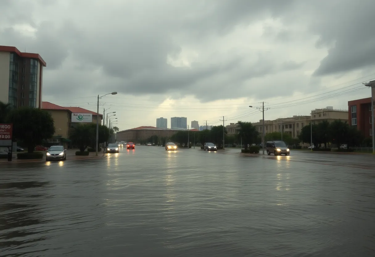
Lexington and Richland counties in South Carolina are under a flash flood warning due to heavy rainfall from ongoing thunderstorms. The National Weather Service has warned that 1.5 to 3 inches of rain have already fallen, with an additional 1 to 2 inches expected. Residents are advised to stay alert and avoid driving through flooded areas, as significant flooding risks are present in urban regions and near low-lying areas. Communities should prepare for possible evacuations and stay updated on weather alerts during this dangerous event.
Flash Flood Warning in Effect for Lexington and Richland Counties, South Carolina
Lexington and Richland counties are on alert as a flash flood warning has been issued by the National Weather Service in Columbia, SC. The warning went into effect on Saturday at 6:56 p.m., and it is expected to remain valid until 9 p.m. tonight.
According to Doppler radar, thunderstorms have been dumping heavy rain in the area, with reports indicating that rainfall amounts have already reached between 1.5 to 3 inches. But that’s not all! An additional 1 to 2 inches of rainfall could still be on the way. This places many in the community at risk for flash flooding in the very near future.
Residents and visitors in the following locations are advised to stay cautious:
- Columbia
- West Columbia
- Cayce
- Springdale
- St. Andrews
- Oak Grove
- Riverbanks Zoo
- West Columbia Riverwalk
- Guignard Park
- Eau Claire
- Seven Oaks
This flash flood warning is particularly relevant for small creeks, streams, urban areas, highways, streets, underpasses, and other low-lying areas. The impact could be significant in areas such as:
- The Five Points area downstream along Rocky Branch Creek.
- Maxcy Gregg Park.
- Areas of the USC campus along the creek.
- The intersection of Pickens and Blossom.
- The intersection of Whaley and Main.
- Areas of the Olympia neighborhood along the creek.
Motorists should be aware that flooding is affecting several major highways. For instance, Interstate 126 is facing challenges between mile markers 1 and 3, and Interstate 26 is experiencing difficulties between mile markers 108 and 112.
Driving through flooded roads is a big no-no. Most flooding deaths happen in vehicles, and even just 6 inches of rapidly moving water can knock someone off their feet. If it’s 12 inches of fast-flowing water, it’s risky for most vehicles to navigate, as they can easily be swept away.
So, if you’re in a flood-prone area, it’s time to consider moving to higher ground. If you have instructions to evacuate, do so promptly. Make sure to lock your home before you leave, and if you have time, disconnect utilities and appliances. Remember to steer clear of basements or rooms with submerged outlets or cords. If you notice any signs of electrical hazards, such as sparks or buzzing sounds, evacuating is not just advised; it’s crucial.
Lastly, residents are reminded to stay tuned into weather updates during this time. It’s always better to stay informed and prepared.
Frequently Asked Questions
What areas are under the flash flood warning?
The warning affects areas in Lexington and Richland counties, including Columbia, West Columbia, Cayce, and others.
How much rain has already fallen?
Rainfall amounts have already reached between 1.5 to 3 inches.
Is it safe to drive during a flash flood?
No, it’s advised to avoid driving through flooded roads as most flooding deaths occur in vehicles.
Deeper Dive: News & Info About This Topic
HERE Resources
Rapid Shelter Columbia Achieves 100th Permanent Housing Placement
Columbia Water Issues Boil Water Advisory for Residents
Weather Impact Alert for South Carolina Regions
Lexington Police Enhance School Zone Safety
Severe Thunderstorm Alert Hits Lexington and Aiken Counties
Lexington County Remembers Devastating Tornado Outbreak
Columbia Hosts Fly for Foundations Charity Event
Aiken, SC Issues Flash Flood Warning Amid Severe Thunderstorms
Lexington Community Reflects on Tornado Resilience
Flood Advisory Issued for Lexington County Due to Heavy Rainfall
Additional Resources
- Island Packet
- Wikipedia: Flash Flood
- WIS News
- Google Search: Flash Flood Warnings
- WACH Weather
- Encyclopedia Britannica: Weather
- WLTX
- Google News: Flash Floods
Author: STAFF HERE LEXINGTON WRITER
The LEXINGTON STAFF WRITER represents the experienced team at HERELexington.com, your go-to source for actionable local news and information in Lexington, Fayette County, and beyond. Specializing in "news you can use," we cover essential topics like product reviews for personal and business needs, local business directories, politics, real estate trends, neighborhood insights, and state news affecting the area—with deep expertise drawn from years of dedicated reporting and strong community input, including local press releases and business updates. We deliver top reporting on high-value events such as Woodland Art Fair, Crave Food and Music Festival, and Railbird Festival. Our coverage extends to key organizations like Commerce Lexington and Blue Grass Community Foundation, plus leading businesses in education, manufacturing, and technology that power the local economy such as University of Kentucky, Toyota Motor Manufacturing, and Lexmark. As part of the broader HERE network, including HEREBowlingGreen.com and HERELouisville.com, we provide comprehensive, credible insights into Kentucky's dynamic landscape.
