South Carolina, August 12, 2025
News Summary
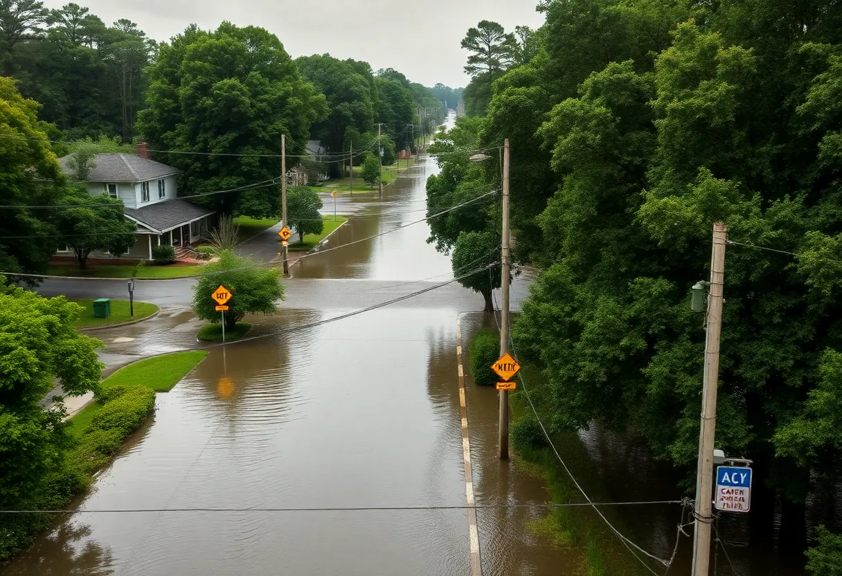
The National Weather Service (NWS) has issued a flood advisory for Lexington, Newberry, and Richland counties in South Carolina due to heavy rainfall. Residents are advised to avoid driving through flooded areas, seek higher ground, and follow evacuation protocols. The potential for hydroplaning and electrical hazards poses significant risks. As recent rainfall has exceeded normal levels, Governor’s Task Force One is prepared for disaster response amidst worsening conditions. The advisory highlights the importance of caution as further rain is expected throughout the week.
Columbia, South Carolina – The National Weather Service (NWS) has issued a flood advisory and warnings for several counties in South Carolina, as heavy rainfall continues to raise concerns for flooding in the region.
As of Monday at 5:40 p.m., a flood advisory is in effect until 7:45 p.m. for Lexington, Newberry, and Richland counties. The NWS warns that excessive rainfall has led to expectations of minor flooding, particularly in low-lying and poorly drained areas. Residents are advised to remain alert and take necessary precautions when faced with flooding conditions.
The NWS emphasizes the dangers of flooding, particularly highlighting vehicle-related incidents, which are a major contributor to flooding deaths. They strongly advise against driving through flooded roadways or around barricades with the message, “Turn around, don’t drown.” Instead, residents in flood-prone areas or campers should seek higher ground and adhere to evacuation instructions.
In cases of evacuation, the NWS recommends residents lock their homes and disconnect utilities and appliances when possible. They also caution against entering basements or rooms with submerged electrical outlets or cords. Signs of electrical faults—such as sparks or buzzing sounds—should demand immediate evacuation, with a strong warning not to enter waters that could carry an electric current. Just six inches of moving water is enough to sweep a person off their feet, while a foot of rapidly moving water can carry most vehicles away.
The advisory follows the updated flood warning issued on Thursday at 10:25 a.m., effective until Friday at 2:37 p.m. This warning is particularly relevant for Greenwood, Newberry, and Saluda counties, where minor flooding is anticipated in lowland areas, including near the Saluda River at Chappells. The NWS indicates that at 14.0 feet, flooding is likely to impact grazing areas near the river, necessitating the relocation of cattle to higher ground.
Motorists are strongly discouraged from attempting to drive around barricades or through flooded regions. The NWS also warns of hydroplaning, a dangerous situation where vehicles slide uncontrollably on wet roads due to water accumulating ahead of the tires.
Recent rainfall totals in the area have surpassed normal levels, with accumulations around 2.49 inches noted in July alone. Additionally, a Weather Impact Alert has been issued for Friday and Saturday due to a forecast of continued heavy rainfall. A cold front is expected to bring multiple opportunities for rain throughout the week.
Heavy rainfall from Friday resulted in flash floods across the Midlands, with numerous reports of stranded vehicles and fallen trees. A flash flood warning remained in effect until 2 a.m. for several counties, including Lexington, Richland, Lee, and Sumter. The hardest-hit spots reportedly experienced near six inches of rain, leading to significant transportation disruptions and hazard warnings.
In the wake of these adverse weather conditions, South Carolina’s Governor has initiated the deployment of Task Force One to Texas, prepared to assist with disaster response efforts stemming from catastrophic flooding in that state. South Carolina’s emergency responders are trained and ready to provide support for national needs in times of disaster.
Frequently Asked Questions
What areas are under flood advisory?
The flood advisory is currently in effect for Lexington, Newberry, and Richland counties.
What precautions should residents take during flooding?
Residents should avoid driving through flooded areas, seek higher ground, lock up homes and disconnect utilities if evacuating, and steer clear of submerged electrical areas.
What should I do if I encounter flooded roadways?
Always turn around and do not attempt to drive through flooded roadways. “Turn around, don’t drown” is key advice to remember.
What is hydroplaning?
Hydroplaning occurs when water builds up ahead of the vehicle’s tires, preventing proper traction and control, making the vehicle slippery and unmanageable on wet surfaces.
How much rainfall has the region experienced recently?
The area has seen approximately 2.49 inches of rainfall in July, with recent storms causing significant accumulations leading to floods.
Key Features of the Flood Advisory and Warnings
| Feature | Description |
|---|---|
| Advisory Issued | Flood advisory effective until 7:45 p.m. for Lexington, Newberry, Richland counties. |
| Warning Areas | Flood warning for Greenwood, Newberry, and Saluda counties. |
| Approximate Rainfall Accumulation | 2.49 inches of rain recorded in July. |
| Hazards Noted | Hydroplaning risk, risks of flooded roadways, and electrical hazards. |
| Upcoming Weather Forecast | Potential for continued heavy rainfall and flash floods on Friday and Saturday. |
Deeper Dive: News & Info About This Topic
HERE Resources
Augusta Faces Flood Advisory as Tropical Storm Erin Approaches
Columbia, S.C. Launches Initiative to Combat Urban Heat
Lexington Police Investigate Surge in Vehicle Break-Ins
Severe Thunderstorm Warning Issued for Lexington and Richland Counties
South Carolina Prepares for Thunderstorms Amid Summer Heat
Columbia, SC Faces Extreme Heat and Thunderstorms on Thursday
Columbia Ordered to Pay $5 Million for Constan Car Wash Closure
Columbia, SC Prepares for Scorching Heat and Thunderstorms
Columbia, S.C. Faces Dangerous Heat Wave and Advisory
Columbia, SC Faces Extended Extreme Heat Alert This Weekend
Additional Resources
- WLTX News
- Wikipedia: Flood
- WISTV News
- Google Search: flood advisory South Carolina
- ABC Columbia News
- Encyclopedia Britannica: Flood
- Live 5 News
- Google News: flood reports South Carolina
- WACH News
- Google Scholar: flooding South Carolina

Author: STAFF HERE LEXINGTON WRITER
The LEXINGTON STAFF WRITER represents the experienced team at HERELexington.com, your go-to source for actionable local news and information in Lexington, Fayette County, and beyond. Specializing in "news you can use," we cover essential topics like product reviews for personal and business needs, local business directories, politics, real estate trends, neighborhood insights, and state news affecting the area—with deep expertise drawn from years of dedicated reporting and strong community input, including local press releases and business updates. We deliver top reporting on high-value events such as Woodland Art Fair, Crave Food and Music Festival, and Railbird Festival. Our coverage extends to key organizations like Commerce Lexington and Blue Grass Community Foundation, plus leading businesses in education, manufacturing, and technology that power the local economy such as University of Kentucky, Toyota Motor Manufacturing, and Lexmark. As part of the broader HERE network, including HEREBowlingGreen.com and HERELouisville.com, we provide comprehensive, credible insights into Kentucky's dynamic landscape.


