News Summary
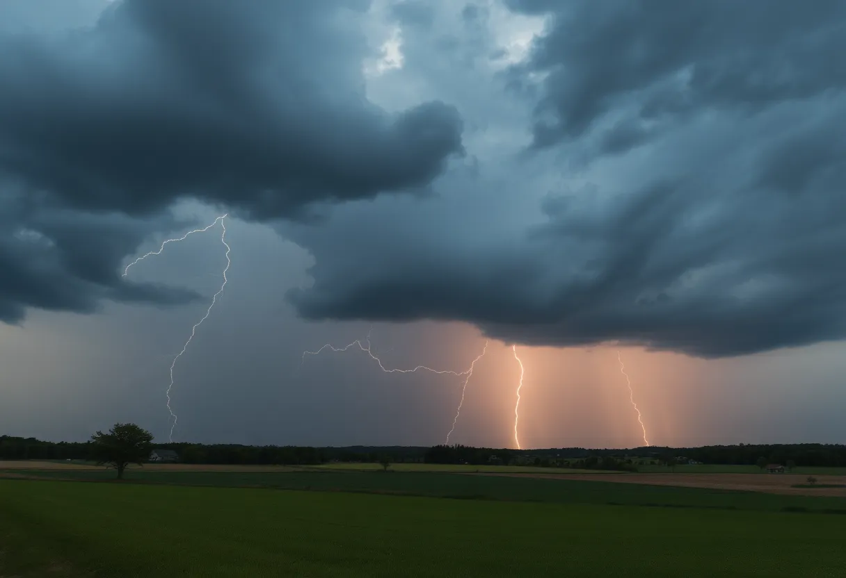
A severe thunderstorm warning has been issued for Aiken and Lexington counties, effective until 2:15 a.m. Storms are bringing quarter-sized hail and wind gusts up to 60 mph. Dangerous conditions are expected, including hail damage, fallen trees, and lightning hazards. Residents are urged to stay indoors and take necessary safety precautions, especially while traveling on Interstate 20. With the possibility of more severe weather alerts later, safety should be a priority for all residents.
Severe Thunderstorm Warning Hits Aiken and Lexington Counties!
Hey folks, if you’re in Aiken or Lexington counties, brace yourselves! The National Weather Service has issued an updated severe thunderstorm warning just past the midnight mark, specifically at 1:58 a.m. The warning is set to be in effect until 2:15 a.m. and it’s packing quite a punch.
What’s Happening Outside?
As we speak, storms are unleashing quarter-sized hail—that’s about 1 inch—and wicked wind gusts reaching up to 60 mph. These storms are no joke! At exactly 1:57 a.m., a severe thunderstorm was spotted near Ridge Spring, just about 7 miles south of Batesburg-Leesville. The storm is currently hustling eastward at around 30 mph.
Expected Damage
Unfortunately, with this kind of weather, we can expect some damage to occur. Hail damage to vehicles is anticipated, and high winds may cause fallen trees and downed power lines. Areas that may be affected by this severe weather warning include:
- Batesburg-Leesville
- Gilbert
- Summit
- Monetta
- Camp Kinard
- Fredonia
- Murray
- Steedman
- Kneece
- Samaria Fire Station
- Cedar Pond Campground
If you’re traveling along Interstate 20 in South Carolina, especially between mile markers 29 and 51, keep your eyes peeled!
Lightning and Safety Precautions
This storm comes with more than just hail and wind; it’s also bringing a hefty dose of cloud-to-ground lightning. When it comes to lightning, you might not know this, but it’s considered one of nature’s top threats, with approximately 25 million lightning strikes occurring across the U.S. each year. About 20 people lose their lives to lightning annually. So, when the storm rolls in, you know it’s time to seek immediate indoor shelter.
And let’s not forget about hydroplaning! It’s when your vehicle starts to slide uncontrollably on those wet roads due to too much water buildup. With rain falling during this storm, that’s another hazard to keep an eye on, especially if you plan on heading out.
What to Do During the Storm?
The NWS recommends moving to an interior room on the lowest floor of your home or building. This is your best bet to stay safe while those storm winds howl and lightning strikes flash.
Future Forecasts
Safety Comes First
Given the forecast, heavy rain and lightning are likely to create hazardous travel conditions, especially during the morning commute. Areas expected to experience the highest wind gusts include Lee, Sumter, eastern Calhoun, Clarendon, and eastern Orangeburg counties. As we deal with these weather concerns, the South Carolina Forestry Commission has issued a statewide burn ban due to high fire danger. It’s a good time to play it safe!
Stay safe, everyone, and keep an eye on the skies! Your safety should always come first in weather like this!
Deeper Dive: News & Info About This Topic
HERE Resources
Severe Weather Approaches North Carolina: Key Alerts
West Columbia to Host 7th Annual Art on State Event
Strong Thunderstorm Alert in Columbia and Surrounding Areas
South Carolina Faces State of Emergency Due to Severe Flooding
Severe Thunderstorms and Tornado Risks in Columbia, SC
Severe Thunderstorm Alert for Lexington and Richland Counties
Governor McMaster Implements Centralized Weather Closure Policy
Severe Weather and Flooding Continues to Threaten Kentucky
Severe Storms Cause Widespread Damage in Minnesota
Warm and Friendly Weather Awaits Central South Carolina
Additional Resources
- Herald Online
- Wikipedia: Severe Weather
- WLTX
- Google Search: Severe Weather in South Carolina
- The State
- Google News: Severe Weather
- WFXG
- Encyclopedia Britannica: Severe Thunderstorms
- WXII 12
Author: STAFF HERE LEXINGTON WRITER
The LEXINGTON STAFF WRITER represents the experienced team at HERELexington.com, your go-to source for actionable local news and information in Lexington, Fayette County, and beyond. Specializing in "news you can use," we cover essential topics like product reviews for personal and business needs, local business directories, politics, real estate trends, neighborhood insights, and state news affecting the area—with deep expertise drawn from years of dedicated reporting and strong community input, including local press releases and business updates. We deliver top reporting on high-value events such as Woodland Art Fair, Crave Food and Music Festival, and Railbird Festival. Our coverage extends to key organizations like Commerce Lexington and Blue Grass Community Foundation, plus leading businesses in education, manufacturing, and technology that power the local economy such as University of Kentucky, Toyota Motor Manufacturing, and Lexmark. As part of the broader HERE network, including HEREBowlingGreen.com and HERELouisville.com, we provide comprehensive, credible insights into Kentucky's dynamic landscape.


